Exploring the legendary Catinaccio area from the Frommer Mountain Hut via the Santner Pass Via Ferrata
Image gallery: Santner Pass Via Ferrata


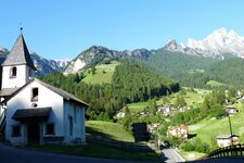
The starting point for our via ferrata tour is the Rifugio Fronza alle Coronelle, a mountain hut in the Catinaccio Group. The new convertible cable car starts in San Cipriano near Tires al Catinaccio and first takes you to Frommer Hut at an altitude of 1,740 metres. Then, take sections 1 and 2 of the Re Laurino Cable Car up to the Rifugio Fronza alle Coronelle, which sits another 600 metres higher up.
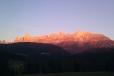
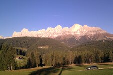
At the top station of the cable car, we follow the signs for the Santner Pass Via Ferrata, first turning left around the Rifugio Fronza alle Coronelle (Kölner Hütte, path no. 550), and then steeply uphill with fixed ropes. We walk north towards the steep rock faces of the Catinaccio. This is the legendary realm of King Laurin and his Rose Garden, which glows in brilliant shades of red and orange every evening at dusk. This Dolomite Glow is known here as Enrosadira, a Ladin name.
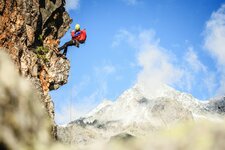
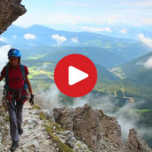
At the first fork, we keep left and stay on the easy path along the mountainside, always following the red markers (542 "S"). The start of the via ferrata is a steep ascent: With some effort, we reach the Santner Pass and its mountain hut. The route requires concentration, caution, and full via ferrata equipment - only the final section is secured with steel cables!
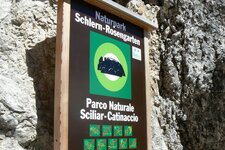
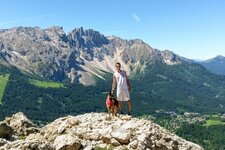
There are also small steps and safety fixtures there. These are missing on the rest of the route, so great care must be taken! Once at the Santner Pass, we descend to the Re Alberto Hut (Gartlhütte) in the Sciliar-Catinaccio Nature Park. The mountaineer Tita Piaz from the Val di Fassa acquired it in 1933 and named it after King Albert I of Belgium, for whom he had served as a mountain guide. The hut, at an altitude of 2,621 metres, provides a wonderful view of the mighty Vajolet Towers.
From here, the path leads steeply down towards the Vajolet Hut (which we do not reach). About 100 metres in altitude above the hut, an unsigned path leads us to the right. This is followed by an exposed section - please proceed with extreme caution! The path now climbs to a fork with a signpost for the Rifugio Fronza alle Coronelle. One final steep ascent, and we reach the Passo Coronelle, a scenic spot that is already in the Trentino Val di Fassa. From here, the trail descends very steeply, and after another 50 minutes, we arrive back at the Rifugio Fronza alle Coronelle.
Authors: Elena & Luca
Experienced in: September 2018
Last updated: 2025
-
- Starting point:
- mountain station of the Re Laurino 2 Cable Car, Fronza alle Coronelle Hut (2,327 m a.s.l.)
-
- Overall time:
- 06:00 h
-
- Total route length:
- 7,6 km
-
- Altitude:
- from 2.327 m to 2.787 m
-
- Altitude difference (uphill | downhill):
- +949 m | -949 m
-
- Signposts:
- 550, 542-S, 541, 550
-
- Destination:
- Passo Santner Hut and Passo Santner (2,787 m a.s.l.)
-
- Resting points:
- Fronza alle Coronelle Hut, Passo Santner Hut, Re Alberto Hut
-
- Recommended time of year:
- Jan Feb Mar Apr May Jun Jul Aug Sep Oct Nov Dec
-
- Download GPX track:
- Santner Pass Via Ferrata
-
- More information:
- Technical difficulty: B/C, difficult in places, especially in the secured sections. Unsecured passages make up about 66% of the via ferrata and require climbing at grades I and II, while the secured sections are mostly in the B range. The overall time shown above refers to the walking time only, not including breaks.
If you want to do this tour, we suggest you to check the weather and trail conditions in advance and on site before setting out.