An interesting themed trail runs at the foot of the highest peaks of the Ortles Alps - Gran Zebrù, Monte Zebrù, and Ortles
Image gallery: Mountain tour on the Solda Glacier Trail


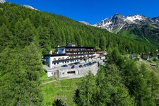
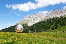
An impressive glacier trail, suitable only for the high summer months, begins in the mountain village of Solda in the Val Venosta. Solda sits at an impressive altitude of 1,896 metres above sea level - no wonder the Tibetan yaks feel at home here. In summer, they are led from the valley station to the Madriccio high pastures. The ice giants of the Ortles Alps tower above the village. We are exploring the highest of them today - Gran Zebrù, Monte Zebrù, and Ortles.
We reach the mountain station and the Città di Milano Hut (status 2026: currently closed as it is for sale) via the Solda Cable Car. From here, we follow the orange-yellow marked wooden posts that indicate the Solda Glacier Trail (Gletscherweg Sulden). They serve as markers because the glaciers are constantly moving - the route is laid out anew every year. We are moving through interesting terrain today - the views on this sunny August day are magnificent!
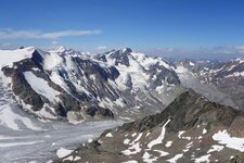
Beneath the trio of peaks Gran Zebrù (3,851 m a.s.l.), Monte Zebrù (3,735 m a.s.l.), and Ortles (3,905 m a.s.l.), we follow the themed trail over scree slopes and past several small glacial lakes. Sturdy footwear and sufficient drinking water are essential here - the path leads over moraines and rubble. Occasionally, the glaciers release relics from the First World War. The highest point of the hike is located in the middle of the glacier trail at over 2,700 metres.
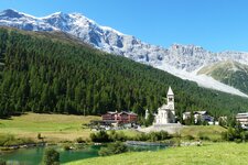
Finally, we reach the Coston Hut (Hintergrathütte), which is managed during the summer months. Here, in the heart of the Stelvio National Park, we treat ourselves to an extended rest. Afterwards, trail no. 2 takes us down into the valley in a relatively short time. Upon our arrival in Solda, we have descended 800 metres in altitude from the hut. An unforgettable experience in the eternal ice!
Author: ED
Experienced: August 2023
Last update: 2026
-
- Starting point:
- Città di Milano Hut, mountain station of the cable car (2,581 m a.s.l.)
-
- Overall time:
- 03:30 h
-
- Total route length:
- 9,8 km
-
- Altitude:
- from 1.896 m to 2.735 m
-
- Altitude difference (uphill | downhill):
- +217 m | -896 m
-
- Signposts:
- orange-yellow marked wooden posts (Glacier Trail), no. 2 (valley path)
-
- Destination:
- Coston Mountain Hut (2,661 m a.s.l.), afterwards Solda (1,896 m a.s.l.)
-
- Resting points:
- Rifugio Città di Milano, Rifugio del Coston huts
-
- Recommended time of year:
- Jan Feb Mar Apr May Jun Jul Aug Sep Oct Nov Dec
-
- Download GPX track:
- Mountain tour on the Solda Glacier Trail
-
- More information:
- The total time given above refers to the pure walking time, without breaks. Please note: The Solda Glacier Trail is re-routed every year, as the glacier is constantly moving.
If you want to undertake this hike, we recommend checking the weather and trail conditions in advance and on site before starting this hike!