The Klapfberg Hut in the upper Val d’Ultimo is a relaxed summer hiking destination: The secluded valley is also home to Lake Binazia
Image gallery: Hike to the Klapfberg Hut and Lake Binazia


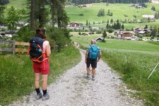
We drive by car into the upper Val d'Ultimo towards Santa Gertrude and park about one and a half kilometres before the village. On the left side of the road are the Falschauern bus stop and a small bridge crossing the Valsura River. We are at an altitude of 1,328 metres: Here, we cross this bridge to reach a small car park.
From the car park, we walk back along the road for about 50 metres and then turn onto path no. 16 towards the Val di Clapa valley. Initially, the path ascends gently, but it becomes increasingly steep until we reach the Klapfberg Hut after about an hour and a half. Here, we keep left and follow path no. 16B towards Lake Binazia (Schrummsee). The trail leads over gravel into a dip and then climbs steeply up to the Binazia Hut, or Schrummalm, an old, unserviced hut.
From there, it is not much further. The mountain lake is also called Lake Clapa or Klapfbergsee and lies at 2,182 metres above sea level. It is one of the many bodies of water in the Val d'Ultimo. Nestled in the quiet mountain landscape, the lake appears quite elongated. Those with enough energy for another hour and a half can climb the summit of Stubele (2,671 m a.s.l.) from here.
We enjoy the tranquility by the lake and then continue along the path. It first climbs a little further, past red and white, partly faded markings, before descending again. A steep path leads back to the Klapfberg Hut. Caution is advised here, as the signposts are sparse on this section. From the alm, we take the same path we used for the ascent.
Interesting fact: A very well-preserved larch trunk was found in Lake Binazia. Its age is astonishing: around 8,000 years. The tree is thought to have grown here around 6506 BC.
Authors: Elena & Luca
Experienced: August 2023
Last update: 2025
-
- Starting point:
- parking space near Santa Gertrude in the Ultimo Valley (1,444 m a.s.l.)
-
- Overall time:
- 04:45 h
-
- Total route length:
- 15,2 km
-
- Altitude:
- from 1.444 m to 2.270 m
-
- Altitude difference (uphill | downhill):
- +866 m | -866 m
-
- Signposts:
- "Klopfberg-Alm", 16, 16B, red and white markings
-
- Destination:
- Lake Binazia (2,182 m a.s.l.)
-
- Resting points:
- Klapfberg Mountain Hut (managed from mid-June to mid-September)
-
- Recommended time of year:
- Jan Feb Mar Apr May Jun Jul Aug Sep Oct Nov Dec
-
- Download GPX track:
- Hike to the Klapfberg Hut and Lake Binazia
-
- More information:
- The destination of the hike is Lake Binazia at 2,182 metres, but the highest point of the tour is 90 metres higher, as the path only descends after that. The overall time shown above refers to the walking time only, not including breaks or stops at mountain huts.
If you want to undertake this hike, we recommend you to check the weather and trail conditions in advance and on site before setting out.