This moderately difficult hike high above the Anterselva Valley rewards you with wonderful views on the surrounding mountains
Image gallery: Hike from Anterselva di Mezzo to the Grente Hut


The starting point of our hike is the sports zone in Anterselva di Mezzo. From there we follow path no. 12 towards the Malga Kumpfl, a mountain hut. Right at the beginning we find the Egger Waterfall, which can be experienced from close up thanks to the short Waterfall Trail.
We continue out of the valley on a moderately ascending forest path. After a good hour's walk, we reach the Kumpfl Hut at 1,654 metres above sea level. Initially still on the forest path, we continue hiking uphill. Soon we turn off onto path 6A towards the Grente Hut. We quickly gain height and enjoy the view towards the head of the valley again and again.
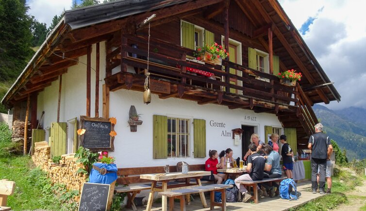
At a junction, we continue along path no. 6A - path no. 6B would lead us to the Ochsenalm Hut and Mt. Montone. In the distance we can already see our destination, the Grente Hut at exactly 2,002 metres above sea level, which we reach after about 90 minutes from the Kumpfl Hut. After a cosy stop for refreshments and a short rest, we return to our starting point along the same route.
Author: AD
Experienced in: August 2023
Last updated: 2025
-
- Starting point:
- Anterselva di Mezzo (1,258 m a.s.l.)
-
- Overall time:
- 04:30 h
-
- Total route length:
- 11,2 km
-
- Altitude:
- from 1.258 m to 2.002 m
-
- Altitude difference (uphill | downhill):
- +891 m | -891 m
-
- Signposts:
- 12, 6A
-
- Destination:
- Grente Mountain Hut (2,002 m a.s.l.)
-
- Resting points:
- Kumpfl Hut, Grente Hut
-
- Recommended time of year:
- Jan Feb Mar Apr May Jun Jul Aug Sep Oct Nov Dec
-
- Download GPX track:
- Hike from Anterselva di Mezzo to the Grente Hut
-
- More information:
- The overall time shown above refers to the walking time only, not including breaks.
If you want to undertake this hike, we recommend checking the weather and trail conditions in advance and on site before starting this hike!