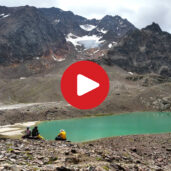
To the lake plateau in the upper Val di Mazia, directly beneath the glaciated peaks of the Punta Saldura
Image gallery: Mountain tour to the Saldura Lakes and the Oberettes Hut


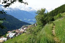
This challenging mountain tour in the Val Venosta takes us to the magnificent Saldura Lakes (Saldurseen) and the Oberettes Mountain Hut. It begins at the Glieshof at the end of the Val di Mazia, home to the certified "Mountaineering Village" of Mazia. The Glieshof itself is a well-known starting point for hikes. Trail no. 1 towards the Saldura Lakes begins there. The path ascends through the forest to a clearing with a wooden fence, benches, and a fountain. After about 40 minutes of walking, we continue for another ten minutes to the junction with trail no. 4.
Here, the hike becomes more strenuous as the path winds steeply uphill. We pass a mountain stream and waterfalls, eventually reaching a plateau and a saddle. From here, the first lake comes into view, and looking further across, we can now spot the other Laghi di Saldura.
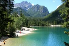
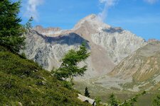
The turquoise water and the surrounding rocks create a wonderful natural scene. The glaciated peaks of the Punte di Saldura in the Oetztal Alps tower above. We now descend to the first lake, with the second one located almost immediately after it. The third lake, the Fischersee (Fisherman's Lake), is also quickly reached. At the far end of the third lake, the short climb to a saddle is worthwhile, offering a chance to view and photograph this natural landscape from above.
From the Fischersee, we follow the red and white trail markers uphill. After 20 minutes, two more lakes appear on the right. The next lake is somewhat more elongated. We walk along its left bank, heading up to the junction where trail no. 1 rejoins our path. It leads to the Passo del Santo, the highest point of our mountain tour (3,097 m a.s.l.). The descent from the pass is steep, with some sections secured with ropes. Sure-footedness and a head for heights are required!
After about 40 minutes, we reach the Oberettes Hut at an altitude of 2,670 metres, 400 metres below the Passo del Santo ridge - this section of the trail is the most challenging. The hut is open from mid-June until the end of September or early October and is a worthwhile stop. From the hut, the path leads downhill through meadows to the valley station of the cable car for materials. A gravel path then takes us to the junction with our ascent route (no. 4). Turning right here leads us back to the car park, which we reach after a two-hour downhill hike from the Rifugio Oberettes.
Authors: Elena & Luca
Experienced in: August 2021
Last updated: 2025
-
- Starting point:
- Glieshof at the end of the Val di Mazia (1,816 m a.s.l.)
-
- Overall time:
- 06:00 h
-
- Total route length:
- 18,1 km
-
- Altitude:
- from 1.816 m to 3.097 m
-
- Altitude difference (uphill | downhill):
- +1379 m | -1379 m
-
- Signposts:
- 1, 4, 7
-
- Destination:
- Saldura Lakes and Oberettes Hut (2,670 m a.s.l.)
-
- Resting points:
- Oberettes Mountain Hut
-
- Recommended time of year:
- Jan Feb Mar Apr May Jun Jul Aug Sep Oct Nov Dec
-
- Download GPX track:
- Mountain tour to the Saldura Lakes and the Oberettes Hut
-
- More information:
- The highest point of the hike is located at the Forcella del Santo ridge at 3,097 metres a.s.l. The overall time shown above refers to the walking time only, not including breaks.
If you want to undertake this hike, we recommend you to check the weather and trail conditions in advance and on site before setting out.