The second-highest peak in Val Passiria can be climbed from Plan as part of a spectacular two-day tour
Image gallery: Mountain tour to the Plan Hut and Mt. Cima delle Anime


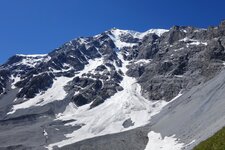
At 3,472 metres, the Cima delle Anime (Hinterer Seelenkogel) is the second-highest peak of the Gurgl Ridge in the southern Oetztal Alps and also the second-highest summit in the Val Passiria - the highest is Mt. Cima Altissima, just eight metres taller. Our tour starts at the car park in Plan, from where trail 6A leads steadily uphill to the beautifully situated Schneid Hut. It serves traditional food, which is why the alm is also a popular hiking destination in its own right.
We cross the Ferner stream twice. After that, the high-altitude tour continues to the Plan Mountain Hut, which sits impressively beneath the glaciated peaks. The final section to the hut at 2,989 metres crosses scree and is partially secured with steel cables. We stay overnight at the Plan Hut. The tour is ideally split over two days, giving us the opportunity to experience the beauty of the mountains at a very special time: sunrise. The next morning, we set off while it is still dark.
The path leads over a wide saddle to the east ridge, then across a partially grassy southern flank and a secured section, continuing to the ridge until we reach a stone staircase. This takes us down into a narrow notch - the narrowest section with steep, exposed ground on both sides. Now the climbing section awaits, which brings us to the summit of the Cima delle Anime. At the top, at 3,472 metres, the ascent rewards us with a fantastic 360° panorama over the Oetztal Alps.
Note: The ascent from the village of Plan via the Plan Mountain Hut (Zwickauer Hütte) and the east ridge, which is from the South Tyrolean side, is the easiest route up the mountain. This route is glacier-free but requires sure-footedness and a head for heights.
Experienced: August 2023
Last update: 2025
-
- Starting point:
- parking space in Plan, Val Passiria (1,623 m a.s.l.)
-
- Overall time:
- 09:00 h
-
- Total route length:
- 13,5 km
-
- Altitude:
- from 1.623 m to 3.472 m
-
- Altitude difference (uphill | downhill):
- +1866 m | -1866 m
-
- Destination:
- peak of Mt. Cima delle Anime (3,472 m a.s.l.)
-
- Resting points:
- Schneid Hut, Plan Mountain Hut
-
- Recommended time of year:
- Jan Feb Mar Apr May Jun Jul Aug Sep Oct Nov Dec
-
- Download GPX track:
- Mountain tour to the Plan Hut and Mt. Cima delle Anime
-
- More information:
- only ascent: 7.5 km and 5 hours