Exploring the awakening nature in western Val Venosta, passing cultural landmarks like the Reichenberg Castle ruins
Image gallery: Hike on the Turnauna Waalweg path


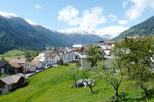
Nature awakening in the valley, snow on the mountains - old villages down below, imposing ruins higher up. This April excursion at an altitude of over 1,200 metres is still a bit too cold to really speak of warm spring days, but it is an extremely interesting discovery tour through the Val Monastero with some beautiful views. We start in the village centre of Tubre.
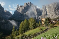
Along the way, we come across three churches: the Parish Church of St. Blaise, the Cemetery Chapel of St. Michael right next to it, and the small Church of St. John. The latter looks back on an eventful history, and its murals and old stone altar are well worth seeing. The Rotund and Reichenberg castle ruins tower above the village. We follow path no. 8, the "Turnauna Waalweg".
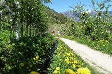
The next section of the path to the Calvenwald forest runs along the irrigation channel across the Turnauna debris cone. These old Waale, as the historic irrigation channels are called, are a vital part of the culture in the Val Venosta: It is a region with low rainfall where fields have been irrigated using this system for centuries. We follow the Sonnensteig path on the sunny slope.
Soon the trees thin out, opening up the view of the Val Monastero valley. At the eastern end, the channel and the path wind down into the valley to the Rio Ram. The Turnauna Waalweg path then ends at a junction on the Calvenboden plain, and we hike back along the same route. We reach Tubre after a total of one and a half hours and treat ourselves to a stop for refreshments.
The hike can alternatively be extended to include the two ruins. To do this, simply climb up path no. 6 via switchbacks to the Rotund Castle ruins and descend back to the starting point via the Reichenberg Castle ruins (adding around 45 minutes and 190 metres of elevation gain).
Author: RB
Experienced: April 2026
-
- Starting point:
- Tubre in the Val Monastero (1,218 m a.s.l.)
-
- Overall time:
- 01:30 h
-
- Total route length:
- 3,7 km
-
- Altitude:
- from 1.218 m to 1.252 m
-
- Altitude difference (uphill | downhill):
- +103 m | -103 m
-
- Signposts:
- no. 8, "Waalweg Turnauna"
-
- Recommended time of year:
- Jan Feb Mar Apr May Jun Jul Aug Sep Oct Nov Dec
-
- Download GPX track:
- Hike on the Turnauna Waalweg path
-
- More information:
- The overall time shown above refers to the walking time only, not including breaks or stops.
If you want to undertake this hike, we recommend checking the weather and trail conditions in advance and on site before starting this hike!