The panoramic summit of the Speikspitze in the Texel Group is a worthwhile destination for a circular hike
Image gallery: Summit tour to Mt. Speikspitze


.JPG)


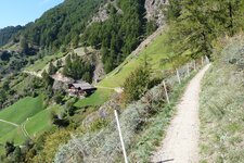
San Martino in Passiria is our destination today for a panoramic hike on this somewhat overcast September day. To be precise, we drive as far as the Rappenhof in Valclava, a hamlet which is already located at an altitude of almost 1,300 metres. The Speikspitze, a medium-difficulty hiking destination, towers about 1,000 metres above us. The area here in the Texel Group is accessible to hikers who wish to remain at lower altitudes via the Merano High Route.
Trail no. 4 leads us quite steeply upwards right from the start. We work up a sweat and feel the energy needed for this mountain hike: A narrow path and a trail leading past several mountain streams - one of which is the Rio Clava, or Kalmbach - take us up to the heights. The first point we reach is the Faglsalm Hut at 1,980 metres, an idyllically situated little alpine hut.
It lies below Lake Faglssee and is managed in summer, but we hike directly on to the lake and then towards the summit. The terrain is relatively steep but less exposed than on other summit tours. Once arrived at the Speikspitze, unfortunately little remains of the panoramic view: The surroundings are engulfed in fog. We start our return journey after a rest. We hike back to the Faglsalm Hut in a loop via the Giogo di Saltusio (Saltauser Joch, trail no. 4).
From there, trail no. 6 takes us to the ridge and then downwards as 6a into the valley. The path goes steeply down along the slope to the Naserhof, which represents another refreshment stop. From there we follow the road northwards to get back to our car park. More than four hours through a wonderful alpine landscape lie between the start and the finish - we want to come back next summer on a day with better weather. Incidentally, in winter the Speikspitze invites you to a moderately steep ski tour with a dreamlike panoramic view from the summit.
Experienced: beginning of September 2021
Last update: 2026
-
- Starting point:
- "Rappenhöfe" parking space, Valclava (1,285 m a.s.l.)
-
- Overall time:
- 04:20 h
-
- Total route length:
- 11,3 km
-
- Altitude:
- from 1.285 m to 2.330 m
-
- Altitude difference (uphill | downhill):
- +1191 m | -1191 m
-
- Signposts:
- no. 4, 6, 6a
-
- Destination:
- summit of Mt. Speikspitze (2,330 m a.s.l.)
-
- Resting points:
- Faglsalm Hut, Naserhof
-
- Recommended time of year:
- Jan Feb Mar Apr May Jun Jul Aug Sep Oct Nov Dec
-
- Download GPX track:
- Summit tour to Mt. Speikspitze
-
- More information:
- The total time given above refers to the pure walking time, without breaks.
If you want to undertake this hike, we recommend you to check the weather and trail conditions in advance and on site before setting out.