A beautiful, moderate mountain hike to Mount Piz Lad promises a special experience: the sunrise
Image gallery: Sunrise hike to the Piz Lad


Even in daylight, the Val di Roia valley is a well-known destination. It branches off from Lake Resia near Curon Venosta and leads into the Sesvenna Alps. We set off while it is still dark from the Malga di Resia car park for a guided hike up Mt. Piz Lad to watch the sunrise on this August day.
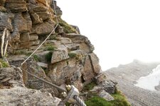
Now, the ascent begins. Equipped with headlamps and jackets to ward off the cold, which can be biting even in August, we follow path no. 4 for an hour to the Resia Hut (Rescher Alm) at an altitude of 2,000 metres. When we arrive in complete darkness, the mountain hut is, of course, still closed. During the day, however, hikers, mountain bikers and walkers stop here - as do tobogganers, snowshoers and ski tourers in winter - to enjoy some hearty South Tyrolean food.
Beyond the mountain hut, we first walk a short way along the military road until path no. 5 branches off. This path leads up to the summit of Mt. Piz Lad at an altitude of 2,808 metres. The mountain is located in the tri-border area of Italy, Austria and Switzerland, making it an excellent vantage point. It also marks the northernmost point of the Sesvenna Alps. The actual border point where the three countries meet is about 700 metres lower than the summit.
We reach the summit before sunrise and are captivated by its beauty and silence. All around us is the tranquillity of the Val Venosta Mountains. Far below in the valley, Lake Resia is visible, and further away are the Grünsee and Schwarzsee lakes near Nauders, which are in North Tyrol. After this memorable experience at the summit, it is time to head back down into the valley. For the descent, you can either take the same route back or - as we did - choose the alternative via the southern ridge towards the Grubenjoch. Shortly before the ridge, the path descends in a series of switchbacks and rejoins the ascent route. After 5.5 hours, we are back at our starting point.
Experienced: August 2022
Last update: 2025
-
- Starting point:
- parking space of the Resia Mountain Hut
-
- Overall time:
- 05:50 h
-
- Total route length:
- 15,1 km
-
- Altitude:
- from 1.789 m to 2.808 m
-
- Altitude difference (uphill | downhill):
- +1126 m | -1126 m
-
- Signposts:
- n. 4, sentiero militare, n. 5
-
- Destination:
- peak of Mt. Piz Lad (2,808 m a.s.l.)
-
- Resting points:
- Resia Mountain Hut (by day)
-
- Recommended time of year:
- Jan Feb Mar Apr May Jun Jul Aug Sep Oct Nov Dec
-
- Download GPX track:
- Sunrise hike to the Piz Lad
If you want to undertake this hike, we recommend you to check the weather and trail conditions in advance and on site before setting out.