The high-alpine Lago di Rasass is located in the Sesvenna area of the Val Venosta and is accessible from the San Valentino alla Muta Hut
Image gallery: Mountain tour to the Green Lake and Lake Rasass


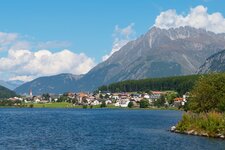
This glorious mountain tour in the Val Venosta shows us the full late-summer beauty of the Sesvenna area before autumn sets in: At these altitudes, it can snow early. We take the cable car that starts in San Valentino alla Muta and takes us to the San Valentino Hut (Haider Alm): In winter, this alpine pasture is a popular ski resort. The hut still presents itself in its summer beauty, with a panoramic view of the Val Venosta with Lake Resia and Lake San Valentino alla Muta.
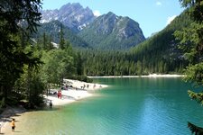
We take path no. 16, which leads uphill from the mountain station. For the first five to ten minutes, it is a forest road, after which the path turns right (still no. 16) and follows the ski slope upwards to a small saddle. It then goes slightly downhill and then uphill to the Lago Verde, literally the Green Lake (Grüner See). We reach it after an hour's walk from the mountain station.
Incidentally, there are several lakes called Lago Verde in the west of South Tyrol, including one in the Val d'Ultimo and one in the Martello Valley, but neither of these is connected to our Lago Verde. We search in vain for signposts to Lake Rasass and continue hiking westwards, at times without a discernible trail. We follow the shepherds' tracks, always staying at the same altitude.
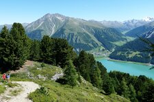
Afterwards, the route goes uphill to a saddle and then, with some ups and downs, to Lake Rasass below Mt. Cima di Rasass. We are at 2,700 metres above sea level, and to the east, the view opens up to the spectacular landscape of the Oetztal Alps. We ourselves are in the Sesvenna Alps.
For the return journey, we choose the shepherds' paths to a hut, after which the trail leads left back to the Malga San Valentino alla Muta Hut, which is the only place to stop for refreshments on this mountain tour. Here, local delicacies are served. Note: Up to the Green Lake, it is an easy hike - afterwards, GPX data or another point of reference is needed. As it is a high-alpine tour, it is officially classified as difficult. Please consult the mountain weather forecast beforehand!
Authors: Elena & Luca
Experienced in: September 2018
Last updated: 2025
-
- Starting point:
- Malga San Valentino alla Muta mountain station (2,151 m a.s.l.)
-
- Overall time:
- 04:00 h
-
- Total route length:
- 13,0 km
-
- Altitude:
- from 2.151 m to 2.705 m
-
- Altitude difference (uphill | downhill):
- +937 m | -937 m
-
- Signposts:
- 16, shepherds' trails (no signposts)
-
- Destination:
- Lake Rasass in the Zerz Valley (2,705 m a.s.l.)
-
- Resting points:
- San Valentino alla Muta Hut (starting point)
-
- Recommended time of year:
- Jan Feb Mar Apr May Jun Jul Aug Sep Oct Nov Dec
-
- Download GPX track:
- Mountain tour to the Green Lake and Lake Rasass
-
- More information:
- The overall time shown above refers to the walking time only, not including breaks or stops.
If you want to undertake this hike, we recommend you to check the weather and trail conditions in advance and on site before setting out.