The Rifugio Pio XI alla Palla Bianca is located in the area of the mighty Palla Bianca and the Vallelunga Glacier Education Path
Image gallery: Hike from Melago to the Pio XI alla Palla Bianca Hut


3 nights from 382 € per person
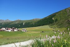
Our autumn hike into the glacier region in the upper Val Venosta begins at the car park in Melago in Vallelunga. The Vallelunga is a side valley of the Val Venosta, branching off near Lake Resia. Path no. 1 takes us along the Vallelunga High Route to the pastures and alpine meadows at the traffic-free head of the valley. We only follow the high-altitude trail for a short distance: Its full 33-kilometre length runs from Curon Venosta to the Pio XI alla Palla Bianca Hut.
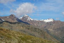
At a junction, we continue on path no. 1A. It soon narrows and proceeds with constant ups and downs along a slope. The view of the mighty Palla Bianca accompanies us. After more than an hour of walking, we finally reach a high plateau. We still have 40 minutes to go to the Pio XI alla Palla Bianca Hut, and the path becomes significantly steeper. Now, we can see the mighty glaciers towering at the head of the valley. A few minutes later, we reach the mountain hut.
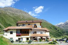
It stands on a terrace at an altitude of 2,542 metres and owes its German name - Weisskugelhütte - to the glaciated Palla Bianca (Weisskugel), the second-highest mountain in the Oetztal Alps. In Italian, however, it is called Rifugio Pio XI, in memory of Pope Pius XI. The hut is managed and open from the end of June to September. These are the last days of late summer suitable for this mountain tour: In bad weather, snow arrives early at these altitudes.
The return journey follows path no. 2, which is the Vallelunga Glacier Education Path. Although it is slightly longer than the route up, its information boards provide interesting details about the nature and habitat we are moving through. It takes us into the glacier area at the head of the valley, where the Gepatschferner, Mt. Vedretta di Vallelunga (3,730 m a.s.l.) and the Punta di Vallelunga, 3,528 metres high, rise majestically. We cross the Rio Carlino on a bridge.
The stream originates in the glacier area, and we soon see exactly where. After that, the path heads downhill. After an initial section through high-alpine terrain, the trail becomes much more pleasant to walk. Before reaching the Melago Hut, we take one last look back: the glaciers once again stand proudly in the setting sun. Shortly afterwards, via the Melago Hut at an altitude of 1,770 metres, we reach Melago (Melag) in the Vallelunga (Langtaufers), our starting point.
Authors: Elena & Luca
Experienced in: September 2021
Last updated: 2025
-
- Starting point:
- car park and bus stop in Melago, Vallelunga (1,893 m a.s.l.)
-
- Overall time:
- 04:30 h
-
- Total route length:
- 11,8 km
-
- Altitude:
- from 1.893 m to 2.544 m
-
- Altitude difference (uphill | downhill):
- +676 m | -677 m
-
- Signposts:
- 1, 1A, 2 (Gletscherlehrpfad)
-
- Destination:
- Pio XI alla Palla Bianca Hut (2,544 m a.s.l.)
-
- Resting points:
- Pio XI alla Palla Bianca Hut, Melago Hut
-
- Recommended time of year:
- Jan Feb Mar Apr May Jun Jul Aug Sep Oct Nov Dec
-
- Download GPX track:
- Hike from Melago to the Pio XI alla Palla Bianca Hut
-
- More information:
- The overall time shown above refers to the walking time only, not including breaks.
If you want to undertake this hike, we recommend you to check the weather and trail conditions in advance and on site before setting out.