This autumn summit hike leads to the Punta di Mezzodì, which stands at the end of the inner Valgiovo valley
Image gallery: Summit tour to the Punta di Mezzodì in Valgiovo


Our autumn hike to Mt. Punta di Mezzodì begins on a beautiful October day in Casalupa in Valgiovo. As this is a mountain tour, we checked the weather beforehand, because at these altitudes, there can already be snow in autumn. Casalupa (Schluppes) and the Punta di Mezzodì (Mittagsspitze) are located in the upper part of the 35-kilometre-long Valgiovo valley.
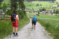
We park the car in one of the few spaces in Casalupa and follow gravel path no. 16 into the valley. An hour and a half of walking lies ahead of us. Initially, the path is still wide and ascends gently. To the right, the meadows of Valgiovo stretch out. After about 10 minutes, we turn left, always following the sign for "Mittagspitz". It is the German name of Mt. Punta di Mezzodì.
A few minutes later, a small sign points to the right, and the path becomes a little steeper. A white and red trail marker leads us into the forest; the gravel path is manageable without much difficulty. After about 45 minutes, we reach a high plateau with a large stone marked in red and white, which we continue to follow. There is also a sign from the Alpine Club indicating a shorter route: We will choose this path for our return journey. The path is somewhat overgrown.
We navigate by the faded red and white markings until we reach another plateau. The markings are sparse: We keep slightly to the left, and then a steep ascent follows to a small saddle. Once at the top, we enjoy the magnificent 360° view: The Cima Libera reveals itself here in all its majestic beauty, as do the Tribulaun di Fleres and the Gran Pilastro, the highest peak of the Zillertal Alps.
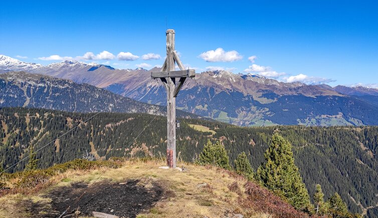
From the saddle, we descend back to the plateau to follow the signs for "Mittagspitz" and, after a short climb, reach the summit at over 2,000 metres in the Sarentino Alps. The summit cross here was erected just over a decade ago. The return journey then follows the AVS path steeply downhill. This route is more direct than the ascent - at least on the way down - and is better signposted. After a walking time of around three hours, not including breaks, we arrive back at the car park.
Authors: Elena & Luca
Experienced: October 2021
Last update: 2025
-
- Starting point:
- parking space in Casalupa, Valgiovo (1,550 m a.s.l.)
-
- Overall time:
- 03:00 h
-
- Total route length:
- 6,8 km
-
- Altitude:
- from 1.550 m to 2.149 m
-
- Altitude difference (uphill | downhill):
- +604 m | -604 m
-
- Signposts:
- 16, "Mittagsspitz", red and white markings
-
- Destination:
- summit of Mt. Punta di Mezzodì (2,149 m a.s.l.)
-
- Recommended time of year:
- Jan Feb Mar Apr May Jun Jul Aug Sep Oct Nov Dec
-
- Download GPX track:
- Summit tour to the Punta di Mezzodì in Valgiovo
-
- More information:
- Be aware of possible snowfall in autumn! The overall time shown above refers to the walking time only, not including breaks.
If you want to undertake this hike, we recommend you to check the weather and trail conditions in advance and on site before setting out.