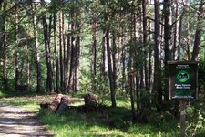
A hike through the forests in the Monte Corno Nature Park takes us up to the Le Malghette Hut, or Krabes Alm
Image gallery: Spring hike from Anterivo to the Le Malghette Hut


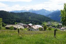
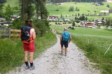
Anterivo in the south of South Tyrol is the starting point for a relaxing hike in the Monte Corno Nature Park. Anterivo is quite unique: Although the municipality belongs to South Tyrol, it is an enclave within Trentino and is only accessible via the San Lugano Pass. We first follow the old, paved path no. 5 towards the Palù Longa. This biotope, at an altitude of 1,452 metres, is surrounded by larch meadows. After this, the path continues pleasantly, and we gain altitude.
We eventually reach the Le Malghette Hut (Krabes Alm) at an altitude of 1,540 metres via forest path no. 6. It is open in summer and serves traditional dishes and delicious desserts. The view from here on the Lagorai Range, a mountain chain, and the Val di Fiemme mountains is splendid and particularly serene on this beautiful May day. The alpine pasture is also the highest point of our hike, although it is one of the lowest-lying huts in South Tyrol.
The hiking signs for the return journey are located by the building: After a delicious break, we opt for a circular tour and follow path no. 9 towards the Passo Cisa saddle, which is a 40-minute walk from the Le Malghette Hut. The path through the forest gradually narrows as we descend. The pass is at an altitude of 1,450 metres, lower than the alpine pasture, and intersects the European long-distance hiking trail E5, which leads from the Monte Corno down into the Mill Valley of Aldino.
Here, the hiking trails intersect, and we follow the path towards Anterivo, where our car park is located. After a few minutes, we pass the lime kiln, which is also situated in the Monte Corno Nature Park (Naturpark Trudner Horn): Local people used to burn lime in this cylindrical kiln. After a successful firing, farmers and traders would come to the forest with their carts to collect the finished lime. Half an hour more, and we have reached our starting point.
Note: The Le Malghette Hut is also accessible from Trodena - this alternative hike takes an hour longer and also leads through the Monte Corno Nature Park.
Authors: Elena & Luca
Experienced: May 2021
Last updated: 2026
-
- Starting point:
- Anterivo village (1,210 m a.s.l.)
-
- Overall time:
- 03:00 h
-
- Total route length:
- 10,2 km
-
- Altitude:
- from 1.210 m to 1.540 m
-
- Altitude difference (uphill | downhill):
- +415 m | -415 m
-
- Signposts:
- no. 5, 6, 9
-
- Destination:
- Le Malghette Hut (1,540 m s.l.m.)
-
- Resting points:
- Le Malghette Hut (May to October/November)
-
- Recommended time of year:
- Jan Feb Mar Apr May Jun Jul Aug Sep Oct Nov Dec
-
- Download GPX track:
- Spring hike from Anterivo to the Le Malghette Hut
-
- More information:
- The overall time shown above refers to the walking time only, not including breaks.
If you want to undertake this hike, we recommend checking the weather and trail conditions in advance and on site before starting this hike!