We combine a three-peak tour with a visit to the second-highest pilgrimage site in Europe
Image gallery: Mountain tour to the Cima San Cassiano


The start of our mountain tour in the Valle Isarco is at the Kuehof car park above Lazfons. It is well known as a hikers' car park and a starting point for tours in this area. Initially, we follow path no. 1. The wide forest track leads up and down until a point where it begins to climb steadily. We soon reach the Chiusa al Campaccio Hut (Klausner Hütte), which sits at an altitude of 1,920 metres on the southern slope of Mt. Cima San Lorenzo in the Sarentino Alps.
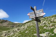
From the hut, the forest path narrows and climbs steeply to a small saddle. Here, there are a few small, privately owned alpine huts and the Runggerer Saltnerhütte hut. Following path no. 1 as indicated by the signposts, we continue to a mountain stream with a bridge. From there, it is a steep 40-50 minute walk to the Santa Croce di Lazfons Mountain Hut (Schutzhaus Latzfonser Kreuz). It is located at an altitude of 2,311 metres, south of the Cima San Cassiano and east of the Passo del Lucolo (2,376 m), a mountain pass between the Valle Isarco and the Val Sarentino.
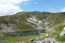
Below lies the pilgrimage site with its church: It is the second-highest pilgrimage site in Europe. From the Santa Croce di Lazfons Hut, we walk back for another five minutes to begin our three-peak tour: Path no. 17 leads us up to the right towards Lake San Cassiano. We follow the tracks to a saddle and then take an unsignposted path on the left to the 2,563-metre-high Cima Sam.
After 15 minutes we reach the summit cross, then head back to the saddle. Next destination: the Cima San Cassiano (path no. 9), 20 minutes from the Cima Sam. Here too, we reach the summit and then look for the path to the third mountain. We hike slightly downhill to a ridge (be careful on the exposed sections!) before immediately ascending again to the summit cross of the Cima Ritzlar, at 2,528 metres. We now descend, partly on sections secured with ropes, until we reach the rifugio. From there, we follow the same path back to the Kuehof car park.
Authors: Elena & Luca
Experienced in: June 2020
Last updated: 2025
-
- Starting point:
- car park at the Kuehof along the road to Villandro (1,545 m a.s.l.)
-
- Overall time:
- 05:30 h
-
- Total route length:
- 18,4 km
-
- Altitude:
- from 1.545 m to 2.581 m
-
- Altitude difference (uphill | downhill):
- +1111 m | -1111 m
-
- Signposts:
- 1, 17, 9
-
- Destination:
- Cima Sam (2,563 m a.s.l.), Cima San Cassiano (2,581 m a.s.l.) and Cima Ritzlar (2,528 m a.s.l.)
-
- Resting points:
- Chiusa al Campaccio Hut, Santa Croce di Lazfons Hut
-
- Recommended time of year:
- Jan Feb Mar Apr May Jun Jul Aug Sep Oct Nov Dec
-
- Download GPX track:
- Mountain tour to the Cima San Cassiano
-
- More information:
- The overall time shown above refers to the walking time only, not including breaks.
If you want to undertake this hike, we recommend you to check the weather and trail conditions in advance and on site before setting out.